


|
Carolina Storm Watch Regional NWS Alerts |
 |
 |
| Images Courtesy Of The NWS | |
|
METRIC | IMPERIAL
|
Updated: Aug-14-2018 @ 9:10pm | ||||||||||||||||||||||||||||||||||||||||||||||||||||||||||||||||||||||
| Temperature | Current Conditions | Forecast / Storm Prediction | |||||||||||||||||||||||||||||||||||||||||||||||||||||||||||||||||||||
|
|
|
|||||||||||||||||||||||||||||||||||||||||||||||||||||||||||||||||||||
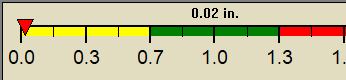
| Dew Point | Liquid Precipitation | Wind Speed | Sun/Moon | ||||||||||||||||||||||||||||||||||||||||||||||||||||||||||||||||||||
|
|
|
|
||||||||||||||||||||||||||||||||||||||||||||||||||||||||||||||||||||
| Humidity | Barometer | ||||||||||||||||||||||||||||||||||||||||||||||||||||||||||||||||||||||
|
|
||||||||||||||||||||||||||||||||||||||||||||||||||||||||||||||||||||||
| Cooling Degree Days | Tide | Heat Index | Air | ||||||||||||||||||||||||||||||||||||||||||||||||||||||||||||||||||||
|
|
|
|
||||||||||||||||||||||||||||||||||||||||||||||||||||||||||||||||||||
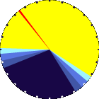
| UV Summary/Forecast | Solar Summary | ||||||||||||||||||||||||||||||||||||||||||||||||||||||||||||||||||||||
|
|
||||||||||||||||||||||||||||||||||||||||||||||||||||||||||||||||||||||
| Almanac | Support this Site! | Station All Time Records | Muggy Meter | ||||||||||||||||||||||||||||||||||||||||||||||||||||||||||||||||||||
|
|
|
Miserable |
||||||||||||||||||||||||||||||||||||||||||||||||||||||||||||||||||||


| 1 Rain season: Jan 1st to Dec 31st. 6 Air Quality Index is provided by Minnesota Polution Control Agency and is updated hourly between the hours of 6AM and Midnight. 10 Historical average only to day 15 of just the month of August for this station since 2001. 11 Historical average rain this season to day 15 of August for this station since 2001. |
| WXSIM Weather Forecast - Outlook Tonight & Wednesday | ||||||||||||||
|
||||||||||||||
|
||||||||||||||
|
||||||||||||||
| Version 6.95 - 05-Jan-2016 - Script Mods by: BurnsvilleWeatherLIVE.com | ||||||||||||||


 |
 |
 |
 |