| WXSIM Weather Forecast - Outlook Tonight & Saturday |
Tonight

Chance rain
Low: 74° |
WXSIM forecast: Fair to partly cloudy in the evening, becoming partly cloudy after midnight. Moderate fog. A slight chance of rain in the evening, then a chance of rain after midnight. Low 74°. Wind southwest around 7 mph, gusting to 21 mph. Chance of precipitation 40 percent. Precipitation mostly around a tenth of an inch.
Local station forecast: Mostly clear with little temp change.
|
Saturday

Thunder storm
High: 82° |
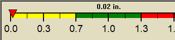
WXSIM forecast: Mostly cloudy in the morning, becoming cloudy in the afternoon. Moderate fog in the morning, then light to moderate fog in the afternoon. A chance of rain in the morning, then rain likely in the afternoon. Scattered thundershowers possible. High 82°. UV index up to 5. Wind southwest around 5 mph in the morning, becoming 9 mph, gusting to 16 mph, in the afternoon. Chance of precipitation 80 percent. Precipitation mostly around an inch. |
|
| WXSIM Short Term Weather Forecast |
|
Saturday
night

Thunder storm |
Sunday

Chance rain
Hot!
|
Sunday
night

Rain likely |
Monday
Rain likely
Hot!
|
Monday
night

Rain likely |
Tuesday
Thunder storm
Hot!
|
Tuesday
night
Chance rain |
| Low: 75° |
High: 89° |
Low: 77° |
High: 85° |
Low: 76° |
High: 87° |
Low: 78° |
|
|
Version 6.95 - 05-Jan-2016 - Script Mods by: BurnsvilleWeatherLIVE.com
|